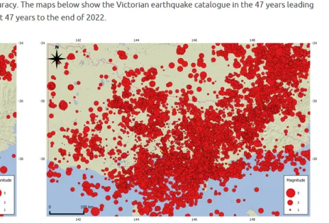
Seismicity of Victoria
For a small state, the state of Victoria has a relatively high degree of seismicity, and some of the events are quite large. Many of the events seem to be connected to the Great Dividing Range. The largest event, the magnitude 5.9 Woods Point event was quite recent (September 2021) and caused widespread damage throughout the local area and into the Melbourne region.
Quite a few relatively large events have occurred in the west and north-western regions of Victoria. A magnitude 4.9 event occurred near Nhill in 1987, and a magnitude 4.8 event occurred near Murrayville in 2021
Many events, some quite large, have originated from the Gippsland and Otway regions of Victoria.
In the 1885 -86 a very significant series of large earthquakes originated from the Bass straight region, between Victoria and Tasmania. The largest was magnitude 6.8 (May 1885).
The map above shows a plot made by the Seismicity Reseach Centre (SRC) in Richmond, Melbourne. It shows earthquakes it has located in Victoria between 1975 and 2022.