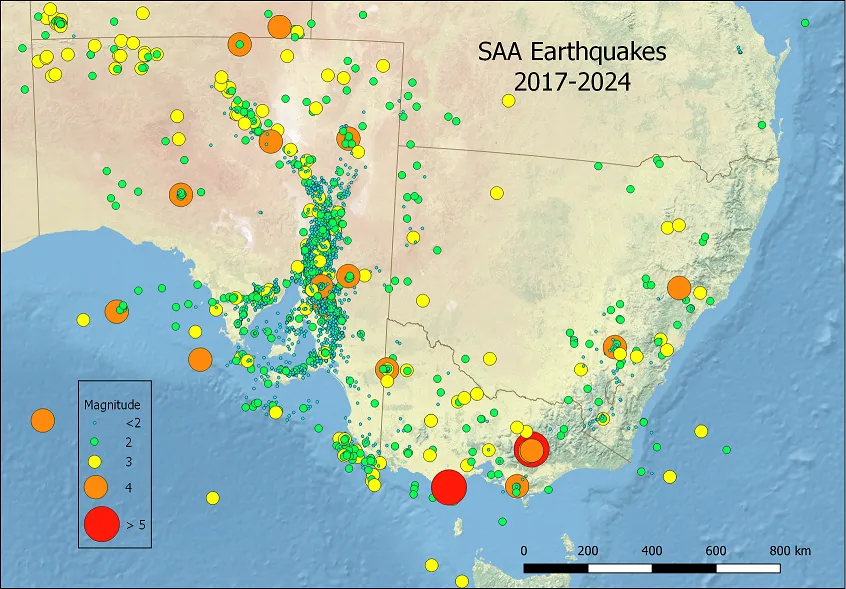
Seismicity of NSW and the A.C.T. The map above shows earthquakes located by the SAA between 2017 & 2024
The largest earthquake in NSW since 1900 was the 1961 Roberstson earthquake (magnitude 5.8), which was felt strongly in the Bowral region, and also in Sydney. It was the largest of several large earthquakes originating from within the Sydney (Geological) basin.
The most significant of the Sydney Basin events was the magnitude 5.4 Newcastle earthquake in December 1989. This event caused extensive structural damage throughout Newcastle and beyond, and resulted in the deaths of 13 people.
Also in the Newcastle area, slightly larger, but not so damaging, was the magnitude 5.3 Ellalong earthquake 5 years later, in August 1994.
A magnitude 5.3 event near Picton in March 1973 was followed by a very long sequence of aftershocks.
Very recently, a magnitude 4.8 event near Muswellbrook also resulted in a long sequence of relatively large aftershocks. From its location, very close to a coal mine, this event is possibly – or probably – mining-related (as was the Ellalong event of 1994).
Many of the larger events in NSW occur along the region of the Great Dividing range, and particularly in the Snowy Mountains region. A magnitude 5.6 event near Dalton (~70 km north of Canberra) in November 1934 caused considerable local damage, and the area remained seismically active for many years afterwards.
Quite a few relatively large earthquakes have been recorded from the far northwest of NSW. The largest of these was probably a magnitude 5.1 event, about 150 km north of Wilcannia, in August 1996.
South Australia
earthquakes in South Australia seem to mostly follow a north-south trending axis, which extends from the Kangaroo Is. and Fleurieu Peninsula region in the south, though the Mt. Lofty and Flinders ranges, and then trends to the north east towards the Northern Territory. However, seismic events are also common in the St. Vincent's and Spencer's Gulfs, and on the Eyre Peninsula. Events located by the S.A.A. in 2023 are shown in the figure above.
The largest South Australian earthquake to date is the 1895 Beachport event (magnitude 6.5). However, the most damaging was the the 1954 Adelaide event (magnitude 5.4). Another region that saw high levels of seismicity in the late 1930's was the Simpson Desert region in the far north-east of the state, and extending into the Northern Territory. six events of magnitude 5.0 and above were recorded in the region between 1937 and 1941, with the largest, magnitude 6.4, occurring in June 1941.
Victoria
For a small state, the state of Victoria has a relatively high degree of seismicity, and some of the events are quite large. Many of the events seem to be connected to the Great Dividing Range. The largest event, the magnitude 5.9 Woods Point event was quite recent (September 2021) and caused widespread damage throughout the local area and into the Melbourne region.
Quite a few relatively large events have occurred in the west and north-western regions of Victoria. A magnitude 4.9 event occurred near Nhill in 1987, and a magnitude 4.8 event occurred near Murrayville in 2021
Many events, some quite large, have originated from the Gippsland and Otway regions of Victoria.
In the 1885 -86 a very significant series of large earthquakes originated from the Bass straight region, between Victoria and Tasmania. The largest was magnitude 6.8 (May 1885).
